搜索结果: 1-15 共查到“工学 support”相关记录311条 . 查询时间(0.126 秒)


New regional centre to support Xe-100 fleet rollout(图)
Xe-100 fleet regional centre X-Energy Reactor Company
2023/3/9

New program to support translational research in AI, data science, and machine learning(图)
人工智能 数据科学 机器学习转化
2023/6/20
中国地质大学科学技术发展院陈伟涛 等,计算机学院. Remote Sensing(2019), Fine Land Cover Classification in an Open Pit Mining Area Using Optimized Support Vector Machine and WorldView-3 Imagery
地质环境;遥感;智能;解译;研究领域
2021/10/15
近日,中国地质大学计算机学院陈伟涛副教授团队再次在地质环境遥感智能解译研究领域取得重要进展。相关研究成果发表在国际著名期刊《Remote Sensing》(2018年影响因子为4.118)。论文第一作者为陈伟涛副教授,通讯作者为李显巨副教授。

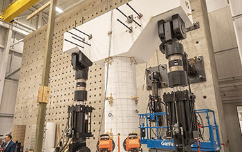
New way for bridges to withstand earthquakes: support column design(图)
New way bridges withstand earthquakes support column design
2019/10/21
Bridges make travel faster and more convenient, but, in an earthquake, these structures are subject to forces that can cause extensive damage and make them unsafe.Now civil and environmental engineer ...
IMAGE CLASSIFICATION FOR MAPPING OIL PALM DISTRIBUTION VIA SUPPORT VECTOR MACHINE USING SCIKIT-LEARN MODULE
Landsat oil palm Python remote sensing Scikit-learn support vector machine
2018/11/9
The world has been alarmed with the global warming effects. Global warming has been a distress towards the environment, thus shorten the Earth’s lifespan. It is a challenging task to reduce the global...
DESIGNING PRECINCTS IN THE DENSIFYING CITY – THE ROLE OF PLANNING SUPPORT SYSTEMS
Data-driven approaches Geographic Information Systems (GIS) Collaborative planning Medium density Digital-planning tools
2018/11/9
Australia’s cities face significant social, economic and environmental challenges, driven by population growth and rapid urbanisation. The pressure to increase housing availability will lead to greate...
USING THE COMBINED LADM-INDOORGML MODEL TO SUPPORT BUIILDING EVACUATION
Indoor modelling UML Access Security LADM IndoorGML
2018/11/9
During an incident, many people that are located in indoor environments require to follow emergency evacuation procedures. The ‘emergency evacuation’ term has been defined as ‘a critical movement of p...
THE LOW BACKSCATTERING OBJECTS CLASSIFICATION IN POLSAR IMAGE BASED ON BAG OF WORDS MODEL USING SUPPORT VECTOR MACHINE
Low Backscattering Objects Bag of Words SIFT features Support Vector Machine
2018/5/16
Due to the forward scattering and block of radar signal, the water, bare soil, shadow, named low backscattering objects (LBOs), often present low backscattering intensity in polarimetric synthetic ape...
REPRESENTING ROAD RELATED LASERSCANNED DATA IN CURVED REGULAR GRID: A SUPPORT TO AUTONOMOUS VEHICLES
curved regular grid road surface terrestrial laser scanning mobile mapping autonomous vehicle transformation
2018/6/4
The terrestrial and mobile laser scanning has become nowadays a mature technology applied in several technical and non-technical applications. The transportation infrastructure can be surveyed by thes...
LAND ADMINISTRATION SUPPORT FOR POST-DISASTER MANAGEMENT
fire hazard land administration monitoring fire management system compensations
2018/4/18
In the Republic of Croatia, especially during the summer times, fire hazards represent a real threat for vegetation and animals but also for material goods and human lives. The most affected areas are...
SOME TOOLS TO SUPPORT TEACHING PHOTOGRAMMETRY FOR SLOPE STABILITY ASSESSMENT AND MONITORING
Active Learning Close-Range Photogrammetry Geohazards Landslide Simulation Low-cost Software Training
2018/4/18
This paper describes the use of some tool to help training of photogrammetry for applications in the field of landslide and slope stability assessment and monitoring. These tools have been used in cla...
SOME TOOLS TO SUPPORT TEACHING PHOTOGRAMMETRY FOR SLOPE STABILITY ASSESSMENT AND MONITORING
Active Learning Close-Range Photogrammetry Geohazards Landslide Simulation Low-cost Software Training
2018/5/8
This paper describes the use of some tool to help training of photogrammetry for applications in the field of landslide and slope stability assessment and monitoring. These tools have been used in cla...
GEOGRAPHIC INFORMATION SYSTEM AND REMOTE SENSING BASED DISASTER MANAGEMENT AND DECISION SUPPORT PLATFORM: AYDES
Disaster Management Decision Support System Geographic Information System Remote Sensing AYDES
2018/4/18
The accelerated developments in information technology in recent years, increased the amount of usage of Geographic Information Systems (GIS) and Remote Sensing (RS) in disaster management considerabl...


