
�������: 1-3 ���鵽��ˮ�ĵ���ѧ study����ؼ�¼3�� . ��ѯʱ��(0.275 ��)
FLOOD VULNERABILITY REDUCTION, USING A PARTIAL PARTICIPATORY GIS APPROACH. A STUDY CASE IN BAJA CALIFORNIA SUR, MEXICO
Participatory cartography loods cyclones vulnerability reduction
2018/4/18
A partial participatory GIS approach was implemented in a community in La Paz, Baja California Sur, Mexico to reduce vulnerability of floods caused by cyclones. A workshop was held to locate areas sus...
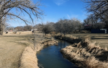
How much water flows into agricultural irrigation?New study provides 18-year water use record��ͼ��
water flows agricultural irrigation 18-year water record
2017/10/26
Irrigation for agriculture is the largest use of fresh water around the globe, but precise records and maps of when and where water is applied by farmers are difficult to locate. Now a team of researc...
Kriging of Groundwater Levels �C A Case Study
Geostatistics Groundwater levels Semivariogram Kriging India
2015/8/11
In this paper, application of the spatial statistical technique, kriging, for the spatial analysis of groundwater levels is shown. The data set consists of groundwater levels measured at about 60 poin...
�й��о����������а�-��
- ���ڼ���...
�й�ѧ���ڿ����а�-��
- ���ڼ���...
�����ѧ���л������а�-��
- ���ڼ���...
�й���ѧ���а�-��
- ���ڼ���...
�ˡ���-ƪ
- ���ڼ���...
�Ρ���-ƪ
- ���ڼ���...
��������-ƪ
- ���ڼ���...
�������� -ƪ
- ���ڼ���...
֪ʶҪ��-ƪ
- ���ڼ���...
���ʶ�̬-ƪ
- ���ڼ���...
��������-ƪ
- ���ڼ���...
ѧ��ָ��-ƪ
- ���ڼ���...
ѧ��վ��-ƪ
- ���ڼ���...