搜索结果: 1-15 共查到“知识库 森林地理学”相关记录75条 . 查询时间(1.875 秒)
中国林业科学研究院杉木地理种源树轮生长与气候因子的关系研究取得进展
杉木地理种源 树轮生长 气候因子
2022/10/29
在全球气候持续变暖的背景下,树种种源选择已成为人类应对气候变化的重要途径。林业所人工林定向培育创新团队基于我国南方广西柳州武宣县杉木成熟龄种源试验林,结合多个年轮生长性状,调查了杉木年轮宽度和木材密度的年际变化,研究了杉木种源生长与气候因子的关系,取得了一定进展。

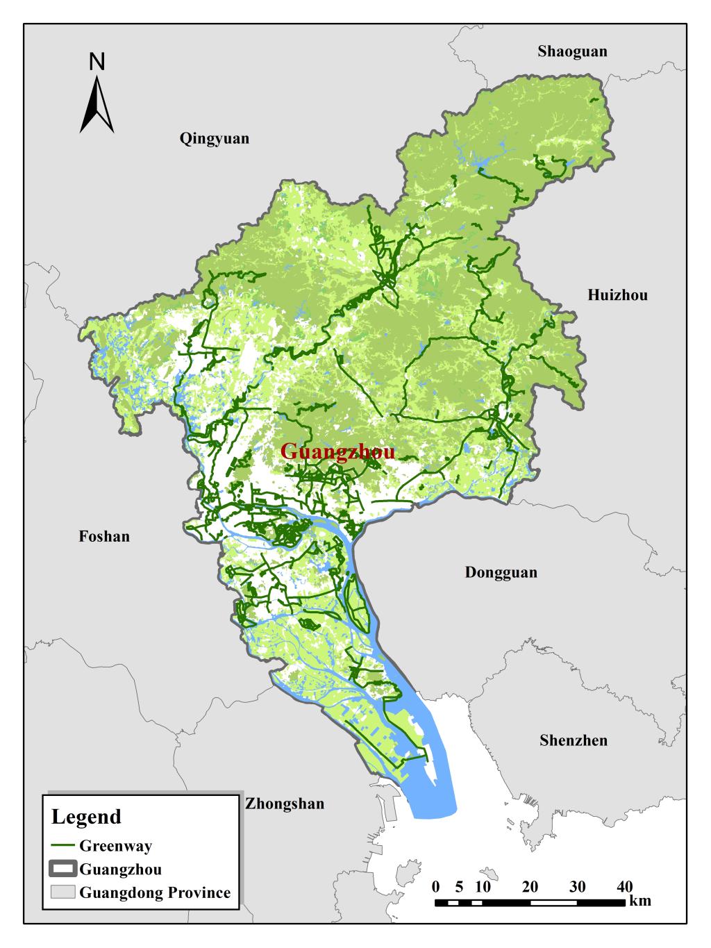
热林所阐明了广州绿道结构特征与供需服务耦合协调的关系(图)
热林所 广州绿道结构 服务耦合
2022/10/29
绿道是重要的城市绿地类型之一,可以在高密度的城市空间中营造出高质量的居住环境,为城市提供生态、社会、文化等多维度服务。热林所以广州绿道系统为研究对象,重点关注绿道结构和绿道服务,综合地理信息系统、景观生态学理论与方法,探究广州市绿道的空间特征,并采用耦合协调度模型对广州市绿道服务供需关系进行验证。研究结果表明:在结构上,广州市绿道呈现“组团—轴带”的空间格局,总体为“南—北”的空间分布,集中分布于...

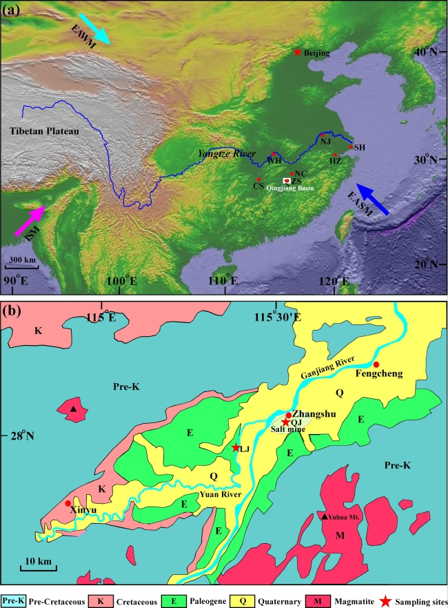
Palaeo-3:孢粉证据揭示江南从荒漠到森林的演变过程(图)
孢粉证据 江南 荒漠到森林 演变过程
2023/1/16

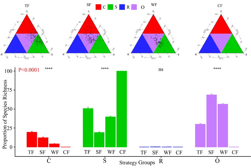
群落构建是生态学家长期以来关注的一个问题。基于功能性状的生态对策谱(类似于生活型谱)综合反映物种–生境关系,有助于理解物种组成和群落构建规律。然而,由于缺乏系统的数据,驱动跨气候区不同森林植被类型的生态对策谱分异的非生物因素难以在观察实验中证实。因此,森环森保所对跨气候区不同森林植被类型进行了一系列的野外调查实验,基于Grime理论及StrateFy计算工具首次构建森林植被生态对策谱,并探究了驱动...

生物多样性与系统发育基因组学团队,负责人:王华锋,教授(破格),博士生导师,南海青年名家,海南省领军人才,崖州湾科技城C类人才,教育部手指柠檬科技小院和海南省科协热带水果产业综合体首席专家,教育部学位论文评估监测专家,美国史密斯学会访问学者。曾先后主持国家自然科学基金面上一项,地区基金两项,青年基金一项,科技部基础科学平台专项一项,海南省重点研发一项,崖州湾科技城菁英人才和南繁专项各一项,科研经费...
林地重金属污染的微生物修复机制
林地 重金属污染 污染来源 微生物修复机制
2021/3/9
林地在维持森林生态系统稳定、保护物种多样性、促进经济发展及保障人民生活等方面起着重要作用。但如今大气干湿沉降、矿区及工业生产污染以及有机肥超量施用等造成的重金属污染问题正日益威胁着森林生态系统正常功能的发挥。微生物在林地重金属污染修复方面具有明显效果,对其修复机制进行研究具有重要的理论意义。文中综述林地重金属污染物的来源及微生物修复机制,介绍微生物对重金属的吸附、累积,通过代谢过程对重金属进行氧化...
Variability in leaf and crown morphology correlated with light availability in five natural populations of Quercus castaneifolia C.A. Mey
plasticity Hyrcanian forest controlled conditions leaf mass leaf area leaf area ratio
2018/3/6
In this study, we investigate seedlings of Quercus castaneifolia C.A. Mey, from five different provenances for the research
on leaf and crown morphological variations in relation to a light gradient ...
Monitoring geometric properties of an existing forest road using airborne Lidar data
vertical profile cross section horizontal profiles total station roadbed
2018/3/6
Accurate information about geometric properties of a forest road is essential for the sustainable forestry and transportation
safety. In this study the ability of airborne Lidar in detecting vertical...
Dynamic growth models for continuous cover multi-species forestry in Iranian Caspian forests
forest statistics forest modelling growth function forest management
2018/3/6
This study concerns some of the relevant topics of the Iranian Caspian forestry planning problem, in particular the first
central components in this modelling process, such as forest modelling, fores...
本文利用2005-2013年林业统计年鉴中每个省市新造林面积和遥感分类提取得到的2010年土地覆被类型,结合公开发表的各类森林生长方程和各个时期的森林存活率,估算了中国新造林在2005-2100年生物量碳库变化及其固碳潜力。结果表明:2005-2013年中国新造林面积达到4394×104 hm2,在自然生长状况下,到2020年新造林蓄积量增加16.8亿m3,生物量增加1.6 Pg,生物量碳库0.7...
Nonlinear mixed effect height-diameter model for mixed species forests in the central part of the Czech Republic
height-diameter relationship multi-layered forest stand model localization Naslund’s model prediction error
2016/11/11
Various forest models that estimate volume, site index, growth and yield, biomass, and sequestrated carbon amounts are based on the information of the tree heights. The tree heights are obtained eithe...
Accuracy of Structure from Motion models in comparison with terrestrial laser scanner for the analysis of DBH and height influence on error behaviour
hand-held digital camera point cloud stem optimization image segmentation photogrammetry
2016/9/2
With the advantage of Structure from Motion technique, we reconstructed three-dimensional structures from two-dimensional image sequences in a circular plot with a radius of 6 m. The main objective of...
Predicting the earthwork width and determining the annual growth loss due to forest road construction using artificial neural network and ArcGIS
area of road earthwork hillside slope roadside rock share
2016/8/2
The area of forest destruction as well as the annual growth loss due to road construction before constructing a road was predicted. To do this, road cross sections of 88 points along the 10 km propose...
A COMPARISON OF OBJECT-BASED AND PIXEL-BASED APPROACHES TO ESTIMATE LIDAR-MEASURED FOREST CANOPY HEIGHT USING QUICKBIRD IMAGERY
Canopy height Geographic object-based image analysis
2015/11/16
Canopy surface height (CSH) is a significant forest biophysical parameter to estimate above-ground biomass and carbon content.
High- spatial resolution optical remotely sensed data have shown promis...
We estimate an equilibrium model
of land clearing to study the impacts of roads and
population on deforestation in Thailand between
1976 and 1989. Population pressures were more
important in the N...


