搜索结果: 1-15 共查到“工学 Monitor”相关记录62条 . 查询时间(0.116 秒)

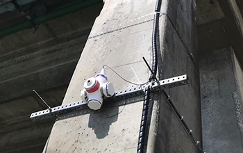
A University of Florida team is starting to gather real-time data on the impact of waves and rising water on bridges during hurricanes. Unlike studies that rely on tests in wave laboratories, this res...
APPLICATION OF GIS AND REMOTE SENSING TO MONITOR THE IMPACT OF DEVELOPMENT ACTIVITIES ON THE COASTAL ZONE OF JAZAN CITY ON THE RED SEA, SAUDI ARABIA
Urbanization Edge images Urban Land Use Infrastructure Growth Multi-Temporal Landsat
2018/4/18
Jazan city is a fast-growing coastal city in the southern part of Saudi Arabia, Red Sea. Recently, it has encountered quick industrial development activities. To monitor these activities, the changes ...
APPLICATION OF GIS AND REMOTE SENSING TO MONITOR THE IMPACT OF DEVELOPMENT ACTIVITIES ON THE COASTAL ZONE OF JAZAN CITY ON THE RED SEA, SAUDI ARABIA
Urbanization Edge images Urban, L Use Infrastructure Growth Multi-Temporal Landsat
2018/5/8
Jazan city is a fast-growing coastal city in the southern part of Saudi Arabia, Red Sea. Recently, it has encountered quick industrial development activities. To monitor these activities, the changes ...
2017年图像处理诊断、监视和控制专题会议(Special Session on Image Processing to Diagnose, Monitor, and Control)
2017年 图像处理 诊断 监视 控制 专题会议
2017/6/23
The session aims to underline the intrinsic connection between complex image processing, on one hand, and three important and interconnected actions: diagnosis, monitoring and control, on the other ha...
APPLYING UAV AND PHOTOGRAMMETRY TO MONITOR THE MORPHOLOGICAL CHANGES ALONG THE BEACH IN PENGHU ISLANDS
UAV beach monitoring Digital Surface Model Tombolo
2016/12/1
Penghu islands, in the southern Taiwan Strait, is a remnant of a middle-late Miocene basaltic shield volcano. We present a procedure to use UAV (Unmanned Aerial Vehicles) to perform photogrammetry sur...
A COMBINED APPROACH WITH SMOS AND MODIS TO MONITOR AGRICULTURAL DROUGHT
Agricultural drought MODIS SMOS soil moisture
2016/11/30
A synergistic fusion of the Soil Moisture and Ocean Salinity (SMOS) L2 soil moisture with the Moderate Resolution Imaging Spectroradiometer (MODIS)-derived land surface temperature (LST) and several w...
Feasibility of collecting 24-h urine to monitor sodium intake in the National Health and Nutrition Examination Survey
24-hour urine sodium excretion NHANES biomarker hypertension sodium intake
2018/12/13
Background: Twenty-four–hour urine sodium excretion is recommended for monitoring population sodium intake. Because of concerns about participation and completion, sodium excretion has not been collec...
Deformation Monitor Based on 3D Laser Scanner
Hazards Monitoring Detection Laser scanning Three-dimensional
2015/12/18
It introduces the methods of deformation monitoring based on 3D laser scanner. The point clouds obtained by multi-period scanning for deformation monitored object are registered. The coordinate system...
Remote Automatic Updating Technology for Client Program of Taxi Monitor System
GIS Automation Monitoring Updating Hardware General Packet Radio Service LPC2214 Embedded System
2015/12/17
This article proposes a scheme which realizes the remote update of the dispersed client program through GPRS network by making use of the IAP (In Application Programming) function of the LPC2214 micro...
Coming to a monitor near you:a defect-free,molecule-thick film
defect-free molecule-thick film
2015/12/7
An emerging class of atomically thin materials known as monolayer semiconductors has generated a great deal of buzz in the world of materials science. Monolayers hold promise in the development of tra...
SAHRIS: using the South African Heritage Register to report, track and monitor heritage crime
SAHRIS heritage crime objects
2015/9/11
South Africa has experienced a recent increase in thefts of heritage objects from museums and galleries around the country. While the
exact number of incidences is not known, the increase in thefts i...
Development of Tools and Techniques to Survey, Assess, Stabilise, Monitor and Preserve Underwater Archaeological Sites: SASMAP
Underwater cultural heritage in situ preservation location
2015/9/11
SASMAP’s purpose is to develop new technologies and best practices in order to locate, assess and manage Europe’s underwater
cultural heritage in a more effective way than is possible today. SASMAP h...
Terrestrial Laser Scanning and Digital Photogrammetry Techniques To Monitor Landslide Bodies
LIDAR Classification Correlation
2015/7/14
Photogrammetry and laser scanning, thanks to significant development in last years, are comparable surveying techniques to generate
- without object contact and with a precision commensurate with sca...
A Real-Time Signal Quality Monitor For GPS Augmentation Systems
Real-Time Signal Quality Monitor GPS Augmentation Systems
2015/6/29
The Local Area Augmentation System (LAAS) and the Wide Area Augmentation System (WAAS) are ground based applications of differential GPS to support aircraft terminal navigation and precision approach.
Ephemeris Protection Level Equations and Monitor Algorithms for GBAS
Ephemeris Protection Level Equations Monitor Algorithms GBAS
2015/6/29
One troublesome failure mode for Ground Based Augmentation Systems (GBAS) is the possibility of large discrepancies between satellite locations in space and the locations derived by the ephemeris data...

