搜索结果: 1-15 共查到“物理学 data”相关记录159条 . 查询时间(0.322 秒)

中国地质大学科学技术发展院刘双,胡祥云* 等 地空学院 Journal of Geophysical Research: Solid Earth, Extracting induced and remanent magnetizations from magnetic data modeling
地磁异常;反演;提取;剩余磁化强度;磁化率
2021/10/20
中国地质大学地空学院刘双副教授、胡祥云教授研究团队在《Journal of Geophysical Research: Solid Earth》上刊发的“Extracting induced and remanent magnetizations from magnetic data modeling”的学术论文,提出了通过地磁异常反演提取剩余磁化强度与磁化率信息的方法。
MINERAL MAPPING USING CHANDRAYAAN-1 HYPERSPECTRAL (HYSI) DATA FROM MARE VAPORUM
Imaging Spectroscopy HySi,Compositional Mapping
2019/2/27
The imaging spectroscopy offers an opportunity to map and discriminate different minerals on the lunar surface which further helps to understand the origin, evolution process, and the crustal composit...
COMPARATIVE STUDY ON DEEP NEURAL NETWORK MODELS FOR CROP CLASSIFICATION USING TIME SERIES POLSAR AND OPTICAL DATA
Deep neural networks CNNs LSTMs ConvLSTMs Crop classification
2019/2/28
Crop classification is an important task in many crop monitoring applications. Satellite remote sensing has provided easy, reliable, and fast approaches to crop classification task. In this study, a c...
ENDMEMBER EXTRACTION OF HIGHLY MIXED DATA USING L1 SPARSITY-CONSTRAINED MULTILAYER NONNEGATIVE MATRIX FACTORIZATION
Hyperspectral Imagery Nonnegative Matrix Factorization Multilayer Nonnegative Matrix Factorization Sparsity Constraint Endmember Extraction
2018/5/11
Due to the limited spatial resolution of remote hyperspectral sensors, pixels are usually highly mixed in the hyperspectral images. Endmember extraction refers to the process identifying the pure endm...
COUPLE GRAPH BASED LABEL PROPAGATION METHOD FOR HYPERSPECTRAL REMOTE SENSING DATA CLASSIFICATION
Graph Label Propagation Semi-Supervised method Classification Hyperspectral Remote Sensing
2018/5/15
Graph based semi-supervised classification method are widely used for hyperspectral image classification. We present a couple graph based label propagation method, which contains both the adjacency gr...
THE RESEARCH ON THE SPECTRAL CHARACTERISTICS OF SEA FOG BASED ON CALIOP AND MODIS DATA
Sea fog Low Cloud Caliop Modis Monitoring Spectral Characteristics
2018/5/15
In view of that difficulty of distinguish between sea fog and low cloud by optical remote sensing mean, the research on spectral characteristics of sea fog is focused and carried out。The satellite las...
DATA QUALITY EVALUATION AND APPLICATION POTENTIAL ANALYSIS OF TIANGONG-2 WIDE-BAND IMAGING SPECTROMETER
Tiangong-2 Wide-band Imaging Spectrometer Remote sensing Data quality Quality evaluation
2018/5/15
Tiangong-2 is the first space laboratory in China, which launched in September 15, 2016. Wide-band Imaging Spectrometer is a medium resolution multispectral imager on Tiangong-2. In this paper, the au...
FEATURE RELEVANCE ASSESSMENT OF MULTISPECTRAL AIRBORNE LIDAR DATA FOR TREE SPECIES CLASSIFICATION
Multispectral Lidar 3D point clouds Intensity Tree Species Classification Feature Analysis
2018/5/11
The presented experiment investigates the potential of Multispectral Laser Scanning (MLS) point clouds for single tree species classification. The basic idea is to simulate a MLS sensor by combining t...
ALTERATION MINERALS EXTRACTION USING AIRBORNE HYPERSPECTRAL DATA CASI AND SASI IN WUYI METALLOGENIC BELT, CHINA
Alteration Minerals Airborne Hyperspectral Wuyi Metallogenic Belt Spectral Feature MTMF CASI and SASI
2018/5/14
Hydrothermal alteration is an important content in the study of epithermal deposit, and its deep part is often accompanied by porphyry mineralization. The objective of research is to mapping the alter...
RESEARCH ON VISUALIZATION OF GROUND LASER RADAR DATA BASED ON OSG
LiDAR Data Visualization OSG Point Cloud Triangulation Network Qt
2018/5/14
Three-dimensional (3D) laser scanning is a new advanced technology integrating light, machine, electricity, and computer technologies. It can conduct 3D scanning to the whole shape and form of space o...
AUTOMATIC EXTRACTION OF ROAD MARKINGS FROM MOBILE LASER-POINT CLOUD USING INTENSITY DATA
Laser Scanning Road Marking Point Cloud High Precision Map Adaptive Threshold Segmentation
2018/5/16
With the development of intelligent transportation, road’s high precision information data has been widely applied in many fields. This paper proposes a concise and practical way to extract road marki...
INFORMATION EXTRACTION IN TOMB PIT USING HYPERSPECTRAL DATA
Hyperspectral data Principal component analysis Historical remains Band math Density slice Morphology
2018/5/16
Hyperspectral data has characteristics of multiple bands and continuous, large amount of data, redundancy, and non-destructive. These characteristics make it possible to use hyperspectral data to stud...
POSSIBILITIES OF THE JOINT USE OF OPTICAL AND RADAR DATA IN FLOOD SPACE MONITORING
Remote Sensing Space Monitoring High Waters Flood Radar Data Radar Polarimetry
2018/5/8
The article gives a brief description of the system of space monitoring of high water and floods. Its main tasks are the operational dynamics of snow and ice cover melting and the passage of flood wat...

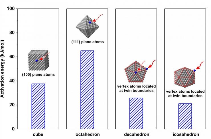
Project Will Provide Reaction Kinetics Data For Deterministic Synthesis Of Metallic Nanocrystals(图)
Reaction Kinetics Data Deterministic Synthesis Metallic Nanocrystals
2018/1/10
Researchers have published the first part of what they expect to be a database showing the kinetics involved in producing colloidal metal nanocrystals – which are suitable for catalytic, biomedical, p...


